 |
| Grays Ferry Crescent |
Philadelphia has 2 major rivers that run through it and alongside it: 1) Schuylkill River (Smaller One), and 2) Delaware River (Larger One).
Almost everyone who lives in/around Philadelphia, as well as those who have visited have no doubt seen the Delaware River before; it’s impossible to miss. It’s our “business” river, it separates PA from NJ, all of our major bridges cross over it, and its very wide (almost looking like a small lake in some spots). Believe it or not, not everyone has truly seen or experienced the Schuylkill River.
The word “Schuylkill” actually holds Dutch roots and translates into “Hidden River.” Rightfully so, for being a decent size river it does have a tendency to stay hidden sometimes (unless you frequent its trails or happen to live in Northwest Philadelphia).
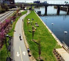 |
| Schuylkill River Trail – Center City, Philadelphia |
From personal experience growing up in the suburbs, but having lived in Manayunk/Roxborough for the last 10 years, I am kind of shocked that people are not familiar with the Schuylkill River, it’s actual location, and where it goes. Reason being, a good portion of this river through Philadelphia is abutted by industrial facilities owned by DuPont and Sunoco. When residents don’t have a connection to their river, it becomes less of a factor within the surrounding area.
I have blogged before about plans for the SRT biking/jogging trail expansion, as well as for economic plans to transform the Lower Schuylkill into a business/industrial hub. But this latest article focuses more on the recreational potential for the entire Lower Schuylkill District.
 |
| Click on the logo to learn more about Schuylkill Banks |


